
self driving excursions around Chania
self driving excursions around Chania
trips around Chania where tourists rarely go
Self-driving trips in Chania district
Drive to Samaria gorge – hike to Agia Roumeli- ferry to Sougia- bus to get back to your car
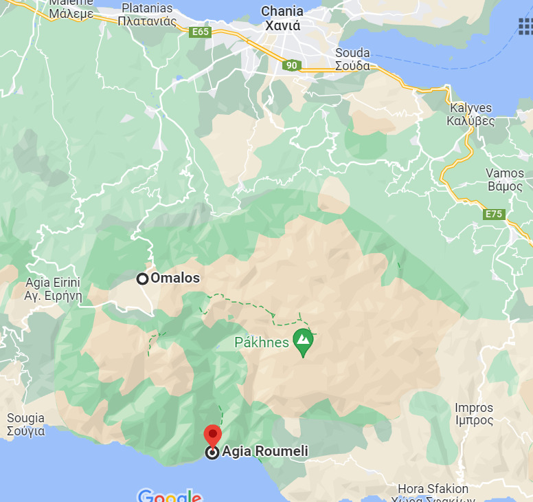
One day round trip
You can drive your own car to the entrance of Samaria Gorge https://www.samaria.gr/, park it at the entrance, hike for 6 hours and exit to South Libyan coast of the island at Agia Roumeli.
The hike starts at 1,250 m in height and goes on for about 16 kilometers until the Libyan Sea.
ATTENTION:
1.Be there at later 8.30 am (if you start late you get baked by heat !)
2. Good hiking shoes!
3. Big bottle with water ( if you have it previous night in the deep frezzer , is better
4.Check you physical condition for hiking
Every afternoon (18.30h), a ferry departing from Agia Roumeli will bring you to Sougia where local buses are waiting for you to bring you back at the gorge entrance where you had left your car !
Samaria gorge ticket to pay at the entrance ( around 15 euros)
Ferry tickets online from Agia Roumeli to Sougia at https://anendyk.gr/
See bus timetable at https://e-ktel.com/en/services/dromologia DEPARTURES FROM SOUGIA & PALEOCHORA
Therisso Gorge – Meskla village
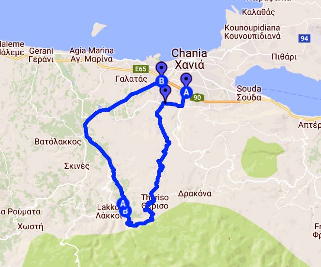
View Therisso gorge -Meskla village in a larger map
Add destination in mobile phone google maps : Theriso gorge
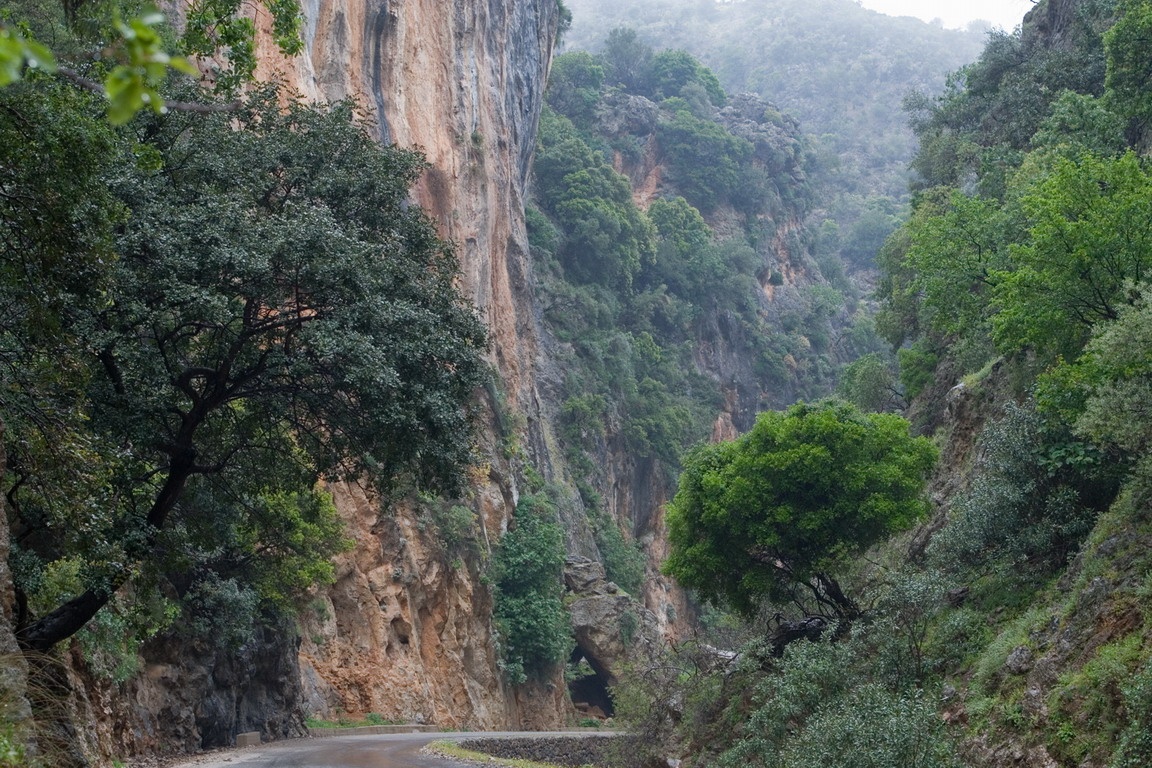
This is the nearest and famous gorge accessible by car at only 10 kms from from Chania .
The road is passes through this gorge for 8 kms , next to small river, and offers ideal places for rock climbers !
There was also a place where at 1944 the partisan forces ambushed the German occupation forces of Crete.
Therisso village is well known for been a center of a revolution for the union with Greece in the early 20th century.
The path to the highest point of the White mountains of Western Crete (2450 meters) starts in Therisso.
From Therisso , continue the road to the village of Zourva with a splendid view over Chania valley and bay.
Continue down the mountain towards the village of Meskla. Before arriving to the village,on the last turn of road, is another small gorge you can walk. After 10 minutes walk you are in the middle of beautiful rock carved pass.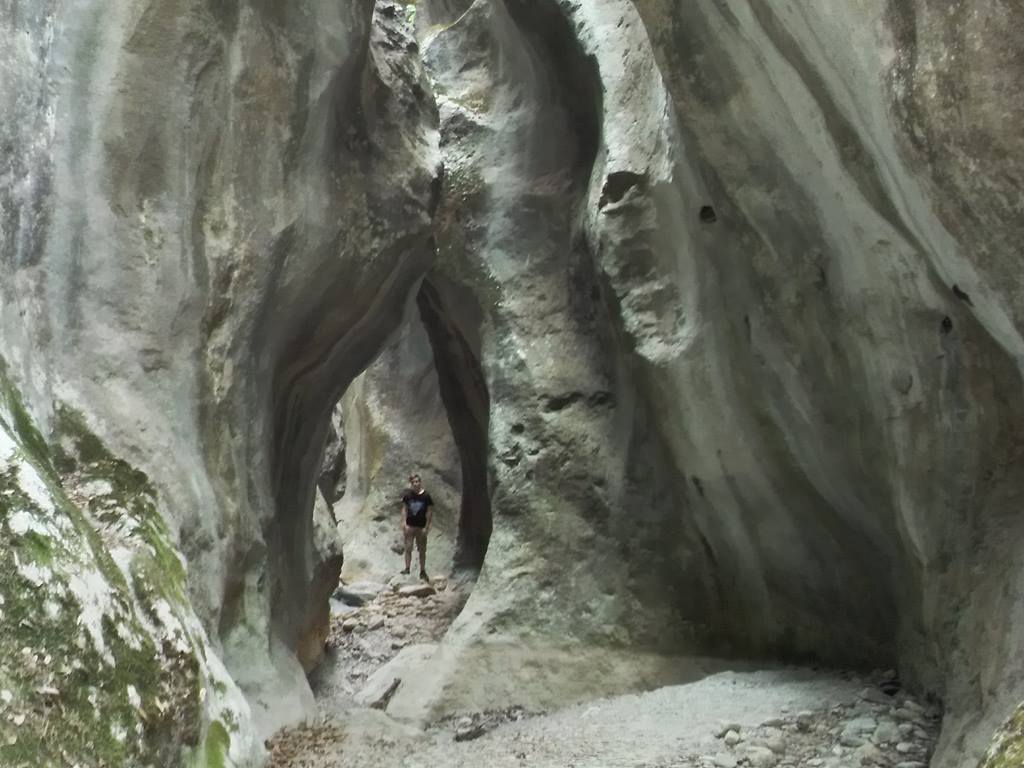
Once in the village, you can enjoy a traditional lunch next to the church under huge trees , and water springs and the river.
You may visit the local church nicely restored and decorated with icons and murals in the Orthodox tradition style .
On the way back to Chania ,the road passes through magnificent country side next to the river, full of orange and avocado trees.
Add destination in mobile phone google maps : Aptera
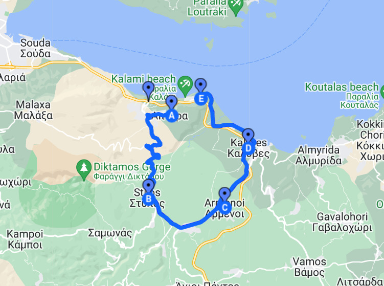
View Itzedin -Aptera -Armeni in a larger map
Add destination in mobile phone google maps : Aptera
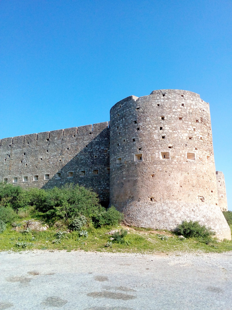
APTERA-ITZEDIN FORTS APTERA ancient city First drive to the end of road and the high walls Turkish fort ITZEDIN situated high on a level plateau with a fantastic panoramic view.
In all directions there is rare beauty to meet the eye, the Cretan sea, the valley of Apokoronas which is exceptionally beautiful, the Akrotiri, and the high White Mountains are all to be seen.
Return to the ancient city of Aperta. The position of Aptera is one of the most impressive in Crete. Mentioned by Homer, the city was renowned for its music. A musical competition was held in the Temple of the Musus between the muses and the sirens.
The Muses emerged victors of the competition but so distressed were the Sirens that their feathers fell out in to the sea and formed the small white islands of Souda Bay.
It is from this legend that the city took its name Aptera meaning wingless. TZITZIKAS and WATER SPRINGS From APTERA new village, drive down towards STYLOS village, then , follow indication panels to the village of ARMENI. Once there, find the hidden cafe of TZITZIKAS . You will have a nice surprise to be in an open cafe, under huge trees and all around the tables, streams of running water of springs with very cold water, coming from water caves -sources from winter snow in the high mountains.
Agia lake -Platanias- Agioi Apostoli
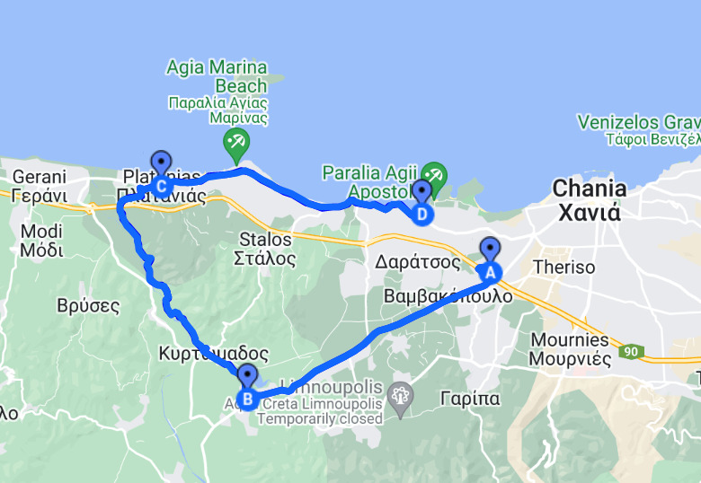
Add destination in mobile phone google maps : Agia lake park
View Agya lake -Platanias- in a larger map
IDEAL FOR BIKING ALL THE WAY !
From the main national highway at the junction to Omalos/Samaria , go towards the Omalos road and continue for 6.5km , just past the large church on your right , turn right for Agia lake. This is a small lake of 450 acres, and receives waters from underground springs and the river Xekolomenos.
It hosts the largest variety of aquatic plants, and is a shelter for many migratory and non-migratory birds. There is a restaurant-cafe and from there is a nice walk by the side of lake on the path on your right.
Drive towards Kirtomados village . From there, select the road to the right to DRAKIANA. Drive under orange and avocado trees and 2 kms later you will find MANOLIS restaurant, next to the river, under Huge trees wich is a beautiful place ideal for barbecues , and offers a children’s playground.
The road ends to the North of PLATANIAS village wich is by the sea and has a large selection of beaches with fine sand.
Drive back to Chania by the old coast road. Agioi APOSTOLI which is 4 kms before the city of Chania , , there is a selection of 4 different beaches , each with a small cafe , clean and quite , far away from hotels, and traffic.
KOLYMPARI- AFRATA- RAVDOUHA
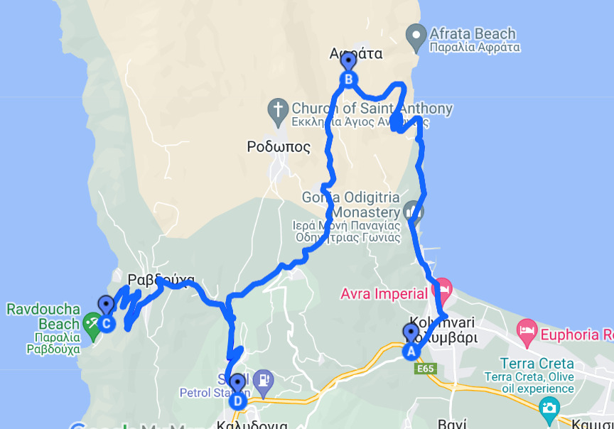
Sheltered from the strong west winds Kolymbari located 22km from the city of Chania. It is well known for the Gonia Monastery dating from 1662. It is a quiet village by the sea side, surrounded by cliffs of the massif of Kissamos peninsula. A path along the sea front with pebbles leads to traditional taverns and cafes. Driving straight north, all along is a magnificent view over the whole gulf of Chania.
If the day of your visit are strong Western winds, then passed village of AFRATA , drive to the small beach and tavern where waters are quite !
From Afrata village, continue the road to Ravdouha at the exact opposite side of peninsula at West .
By the area has several small bays with pebbles and beautiful rock formations. The sea is often affected by the west winds and is ideal for snorkeling. Drive right down towards the sea, then to extreme left where at the end of road there is a charming traditional Greek taverna with freshly caught fish by the owner Theodore. The pebbly beach is protected from the west wind and excellent for snorkeling.
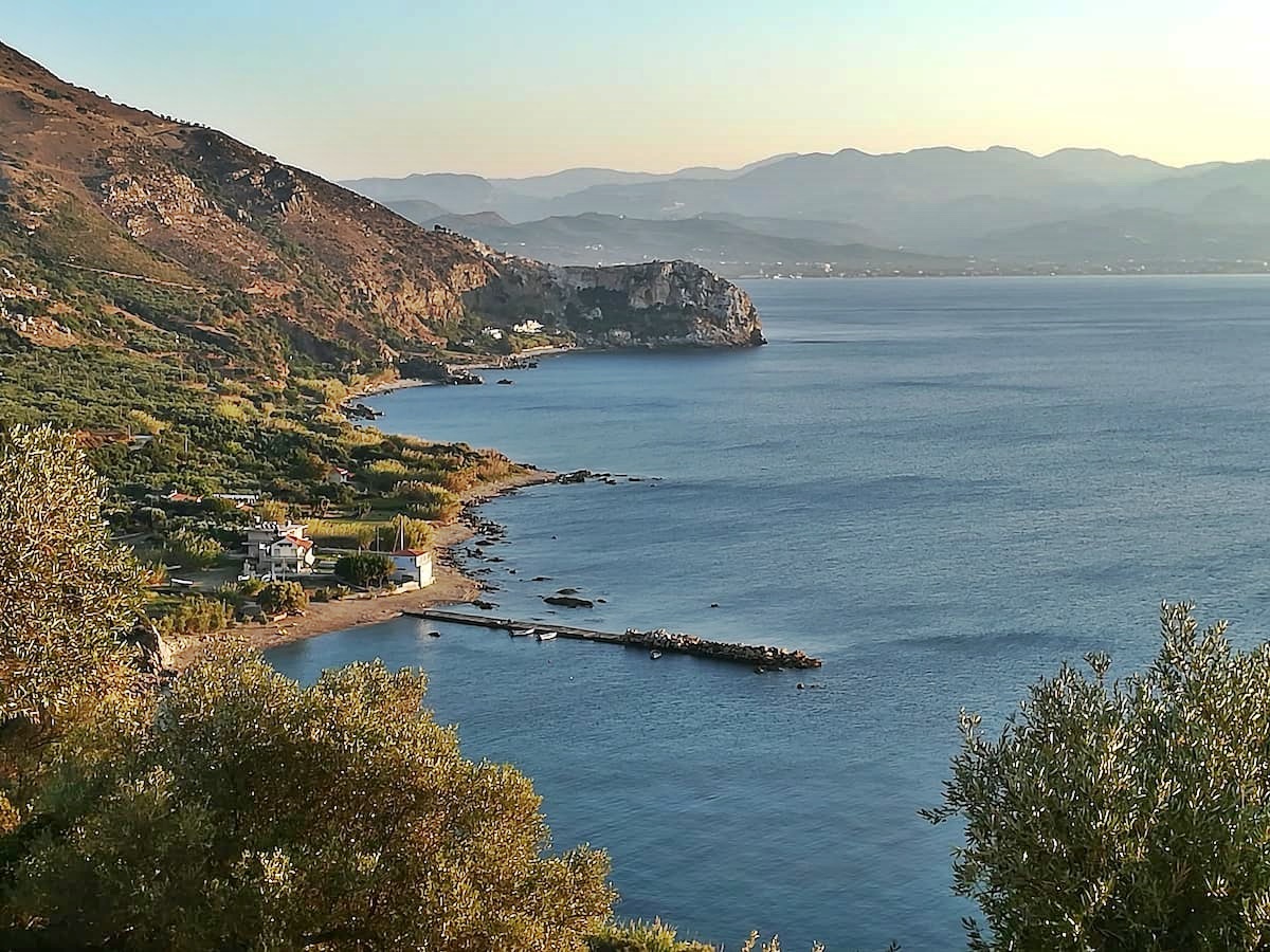
Kournas lake-Argyroupoli- the longest beach of Crete
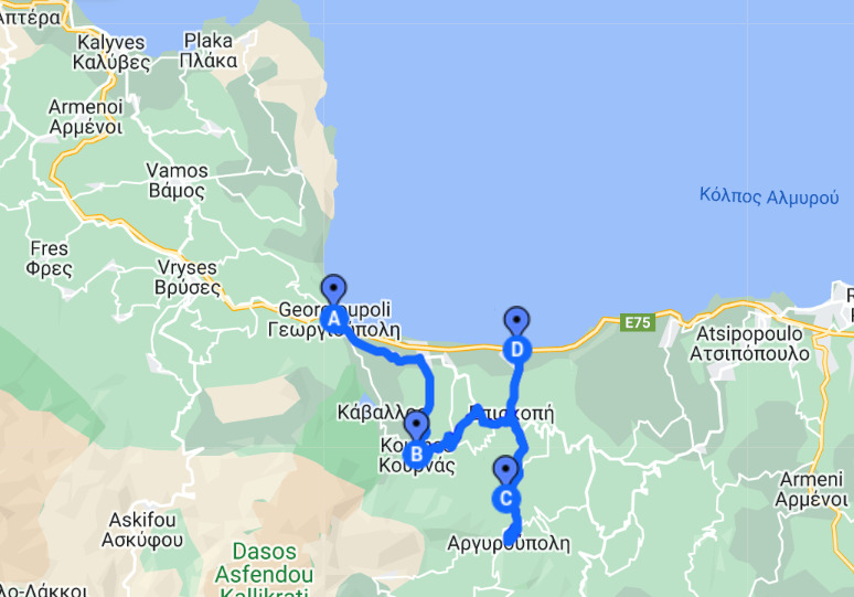
View Kournas lake-Argyroupoli- in a larger map
Kournas lake, is the only freshwater lake of Crete. Is located at 40 km east of CHANIA and 30 km west of RETHYMNON just 3 kms from national road. It covers a total area of about 160,000 sq. m. Vegetation surrounding the scenic lake and the southeastern bank which is lined with olive trees. A strip of white sand on left bank of the lake provides an area for swimming, cafes and a few taverns. Kournas is also suitable for canoe and water-cycling.
Driving towards the high mountains , you pass some picturesque villages then along a small river you reach ancient city of LAPPA , actually called ARGYROUPOLIS. Administration center of the area, flourished during ROMAN period ( where emperor Octavian Augustus in gratitude of help against Marcus Antonius accorded the right of coinage) and remains can be seen at neighborhood of “Barotsiana”.
During the Venetian period Lord Francisco Da Molin set up a trick wedding between his daughter and the son of his Cretan rebel enemy Giorgos Cantanoleos.When the wedding guests were quite drunk 2000 soldiers arrived and proceeded to arrest and hang the guests. Below the village are the springs of the river Petres,
Also the church of the seven virgins and inside a rock under the spring the tiny church of Agia Dynamis ,Saint strength,this alludes to the holy origin of the strength of the water. Enjoy the countryside with huge plane trees and fast running streams used to power the water mills. Here you will find the taverna Mylos very friendly and not at all expensive.
On the way back North to the sea side, passed village Episkopi, you reach again the major National road Heraklion-Chania. Driving towards Chania , you pass on the side of the longest sandy beach of Crete ( 8 kms ) , where you can select any spot for swim alone away from crowds .
Monasteries and Caves
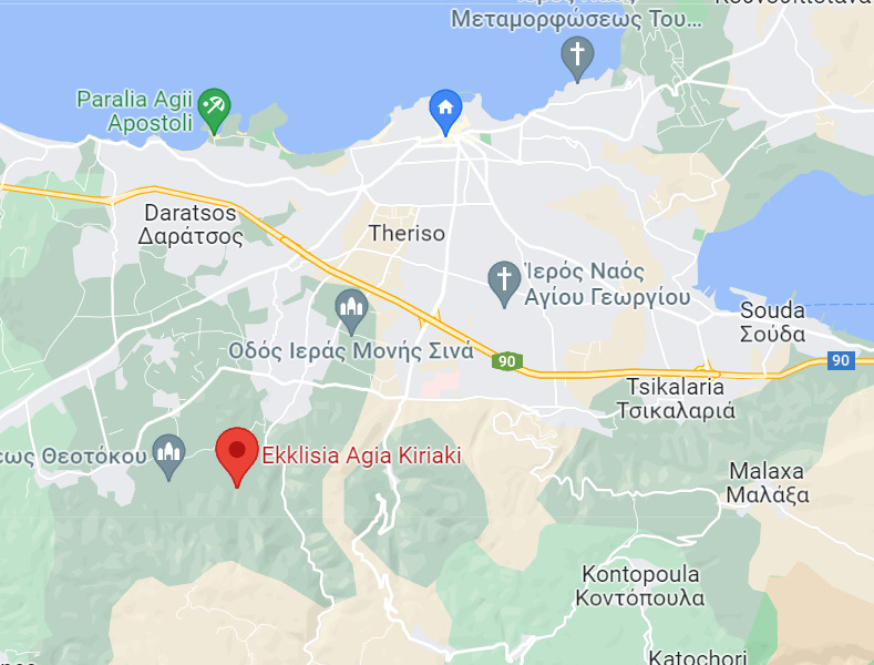
Starting walk point in Google maps Ekklisia Agia Kiriaki, Platia Varipetrou, Nea Kydonia GPS 35.4651621,23.9819755
Wonderfull walk in the country
At 8 kms from Chania, you drive to the ancient Monastery of Agia Kiriaki.
From there , are 2 options for a nice walk . The first is to climb 400 nicely layed stairs to the Monastery of Metamorfosi. Along the path and variation of natural plants, there are small caves transformed in chapels, Once at the top of the hill, with amazing view, you can visit the Monastery where friendly nuns welcome you.
Otherwise, the second option is to walk along the paved path are many natural plants with small explanatory signs in English with their name. At the end of the path there are 200 stairs leading to the cave where is the chapel of Seven saints.